Tsomoriri
The Mountain Lake
General Information
Common Name: Tso Moriri
Other Name: Lake Moriri, District: Leh, State: Jammu & Kashmir, India
Area: 30000 Surface elevation is 4,522 m above sea level
Languages Spoken: Ladakhi, local dialects, English
Long Distance Code: -
Importance: -
Best Time to Visit: June to September and -
International Access: -
Description
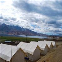
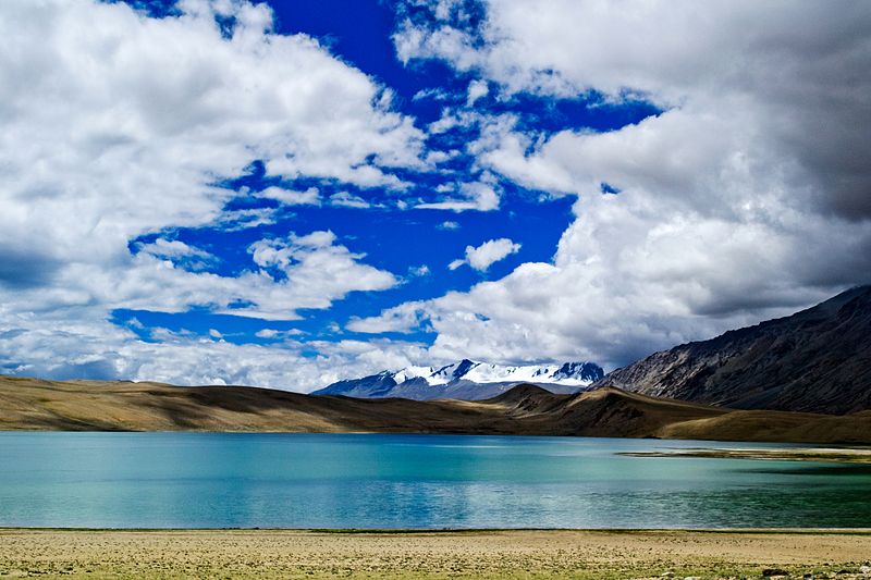
Tso Moriri or Lake Moriri or "Mountain Lake", is a lake in the Ladakhi part of the Changthang Plateau (literally: northern plains) in Jammu and Kashmir to the north of India. The lake and surrounding area are protected as the Tso Moriri Wetland Conservation Reserve. The lake is at an altitude of 4,522 m (14,836 ft). It is the largest of the high altitude lakes entirely within India and entirely within Ladakh in this Trans-Himalayan biogeographic region. It is about 16 miles (26 km) north to south in length and two to three miles (3 to 5 km) wide. The lake has no outlet at present and the water is brackish though not very perceptible to taste. The lake is fed by springs and snow-melt from neighboring mountains. Most water enters the lake in two major stream systems, one entering the lake from the north, the other from the southwest. Both stream systems include extensive marshes where they enter the lake. It formerly had an outlet to the south, but this has become blocked and the lake has become a endorheic lake. The lake is oligotrophic in nature, and its waters are alkaline. Accessibility to the lake is largely limited to summer season, though Karzok on the northwest shore and the military facilities on the eastern shores have year-round habitation.Location
The lake is located to the southeast of Leh in eastern Ladakh, Jammu & Kashmir, at a road distance of 240 kilometres (150 mi). The road is in a good condition for the most part. One can also reach Tsomoriri directly from the Pangong Tso via the remote Changtang region. This is considered to be one of the most beautiful drives in the entire Ladakh region. Foreigners are not allowed to go beyond the Man - Merak villages on Pangong Tso as permits are not issued for them. The distance between Pangong Tso and Tso Moriri is 235 km and there are no petrol pumps in the area. Carrying enough fuel is therefore necessary. Leh is also connected by air with many destinations in India.Climate
Cold, throughout the year

Namgyal Dynasty "Ladakh" / PC-604 (13 Days / 12 Nights)
Delhi-Leh-Uleytokpo-Uleytokpo – Ridzong – Lamayuru – Uleytokpo-Uleytokpo-Leh-Khardongla pass-Nubra (DISKIT & HUNDER)-NUBRA VALLEY-Nubra-Leh-Chumathang – Tsomoriri-Tsomoriri-Korzok-Puga – Tsokar – Tanglangla-Leh-Delhi
Ladakh is a land like no other. Bounded by two of the world's mightiest mountain ranges, the Great Himalaya and the Karakoram, it lies athwart two other, the Ladakh range and the Zanskar range. In geological terms, this is a young land, formed only a few million years ago by the buckling and folding of the earth's crust as the Indian sub-continent pushed with irresistible force against the immovable mass of Asia. Its basic contours, uplifted by these unimaginable tectonic movements, have been modified over the millennia by the opposite process of erosion, sculpted into the form we see today by wind and water. Yes, water! Today, a high -altitude desert, sheltered from the rain-bearing clouds of the Indian monsoon by the barrier of the Great Himalaya, Ladakh was once covered by an extensive lake system, the vestiges of which still exist on its south -east plateau of Rupshu and Chushul - in drainage basins with evocative names like Tso-moriri, Tsokar, and grandest of all, Pangong-tso. Occasionally, some stray monsoon clouds do find their way over the Himalaya, and lately this seems to be happening with increasing frequency. But the main source of water remains the winter snowfall. Drass, Zanskar and the Suru Valley on the Himalaya's northern flank receive heavy snow in winter; this feeds the glaciers whose melt water, carried down by streams, irrigates the fields in summer. For the rest of the region, the snow on the peaks is virtually the only source of water. As the crops grow, the villagers pray not for rain, but for sun to melt the glaciers and liberate their water. Usually their prayers are answered, for the skies are clear and the sun shines for over 300 days in the year. Ladakh lies at altitudes ranging from about 9,000 feet (2750m) at Kargil to 25,170 feet (7,672m) at Saser Kangri in the Karakoram. Thus summer temperatures rarely exceed about 27 degree celcius in the shade, while in winter they may plummet to minus 20 degree Celsius even in Leh. Surprisingly, though, the thin air makes the heat of the sun even more intense than at lower altitudes; it is said that only in Ladakh can a man sitting in the sun with his feet in the shade suffer from sunstroke and frostbite at the same time!
Detailed Itinerary
Day 1 : Delhi-Leh
Day 2 : Leh
Day 3 : Leh-Uleytokpo
Day 4 : Uleytokpo – Ridzong – Lamayuru – Uleytokpo
Day 5 : Uleytokpo-Leh
Day 6 : Leh-Khardongla pass-Nubra (DISKIT & HUNDER)
Day 7 : NUBRA VALLEY
Day 8 : Nubra-Leh
Day 9 : Leh-Chumathang – Tsomoriri
Day 10 : Tsomoriri
Day 11 : Korzok-Puga – Tsokar – Tanglangla-Leh
Day 12 : Leh
Day 13 : Leh-Delhi
Tsomoriri, India Tours