District: Chittoor, State: Andhra Pradesh, India Area: 0 Languages Spoken: Telgu, Hindi Long Distance Code: +91-42837 Importance: Oilseed and Rice milling industries & very near to Tirupati. Best Time to Visit: October to February
Description
Situated in the valley of the Poini River, Chittoor has gained importance because of its proximity to the revered Hindu temple of Tirupati. Chittoor is also a market for grain, sugarcane, and peanuts; its industries include oilseed and rice milling. The city is surrounded by mango and tamarind groves, and cattle are bred in the area. A district administrative centre, Chittoor was a British military post until 1884. <br />It is also very close to the two wild life sanctuaries of Andhra Pradesh viz, the Kaundinya SAnctuary and the Sri Venkateshwara Sanctuary.
Location
Chittoor is located 154-km from Chennai on the southern part of Andhra Pradesh. The southern most district of Andhra Pradesh, Chittor, shares its borders with two states, Tamilnadu in the south and karnataka in the west. The district of Nellore, Cuddapah and Anantpur of Andhra Pradesh, fall in the north and a small tip of the Chittor district seeps into the Bay of bengal on the east.
Chittoor has many wild life sanctuaries nearby.\r\nPocharam: Located in area of 130 sq km, this sanctuary is situated along the shores of Pocharam Lake, near Medak. It is the natural habitat of the cheetah, wild boar, sloth bears, panther, ducks, teals, storks, partridges, quails and flamingos.\r\nGundlabrameshwaram: Around 100 kms from Kurnool, this sanctuary is spread over the vast area of around 1194 sq km. The sanctuary area is situated on Gundlabrahmeshwaram plateau running south-north from 400m msl to 911m msl with cut up and broken hill ranges, valleys and plateaus. The area presents a varied habitat for wildlife. This sanctuary forms part of the Nallamalai Hill ranges. A perennial river Gundlakamma crisscrosses through the sanctuary. The flora consists of teak, bamboo, nallamaddi, a dug chindugu, chirman, yegisa and sheesham.\r\nThe animals found here are Chital, Black Buck, sambhar, neelgai, chousingha, chinkara, mouse deer, langoor, bonnet monkey, pangolin, monitor lizard, python, mugger crocodile, jungle cat, wild dog, hyena, panther and tiger.\r\nSome other sancturaies are the Krishna, Sri Venkateshwara, Srilanka Malleswara and Kaundinga wild life sanctuaries.
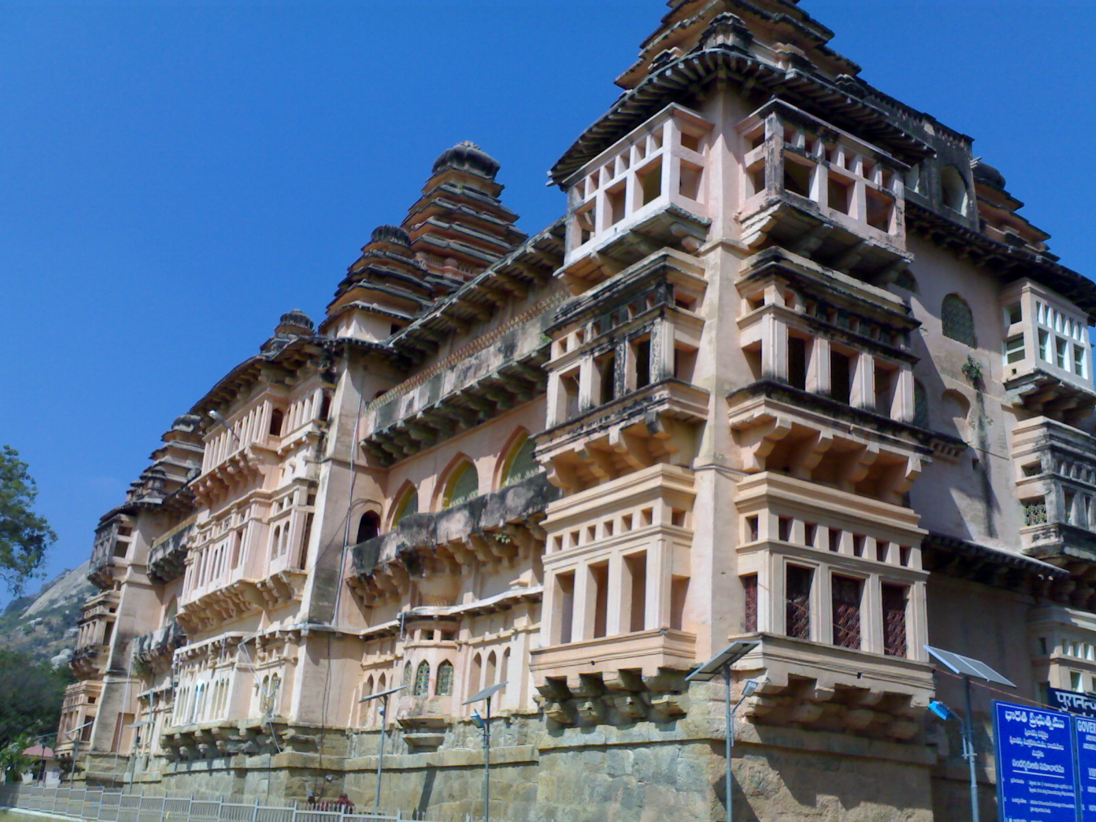
Chandragiri was the former capital of the Vijayanagara Empire. It is located at a distance of 12-km from Tirupati, in Chitoor district. The forts and Mahals at the place are attractions for tourists.
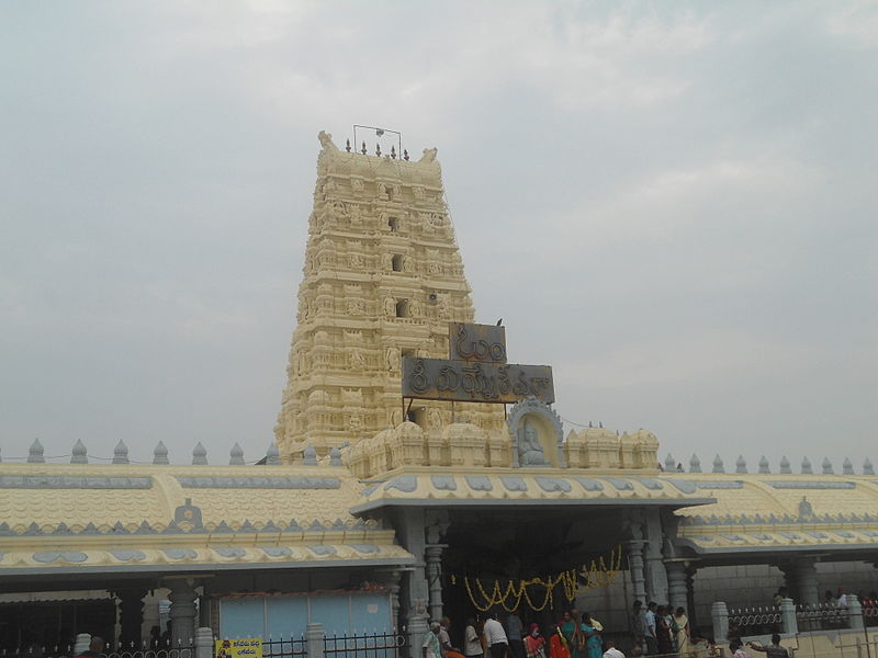
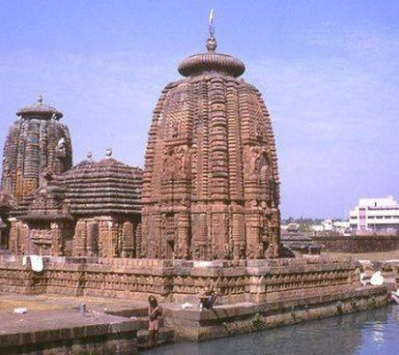
This small village at a distance of about 8-km from Chittoor, is famous for its set of ancient temples dedicated to Mukkantisvara and Lakshminarayana which are believed to have been constructed by the Chola kings, about 1,000 years ago.
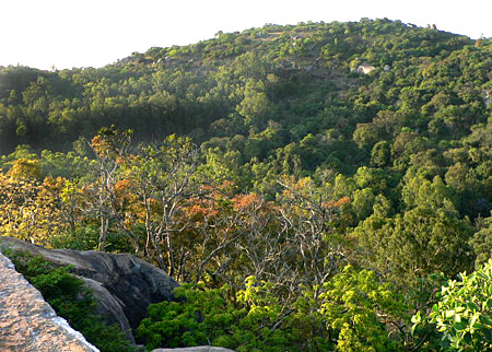
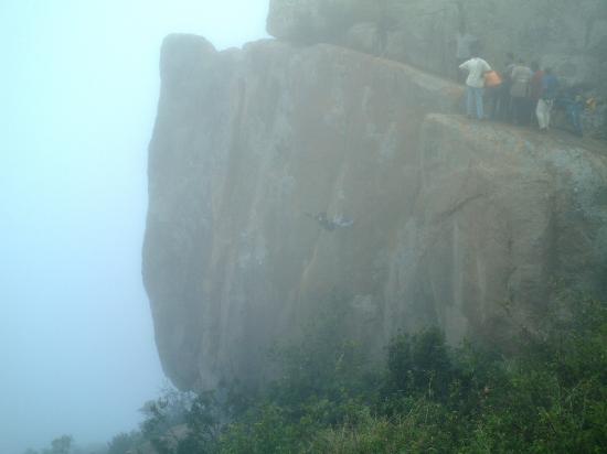
Horsley hills are one of the famous hill resorts of Andhra Pradesh. It is named after WD Horsley, who was the collector of Cuddapah district. Horsley chose this spot for his summer residence. It is situated at an altitude of 1,265 m, which makes this place delightfully cool, with a maximum summer temperature of 32°C, and minimum of 20°C. The shady slopes found in this are wooded with luxurious vegetation.
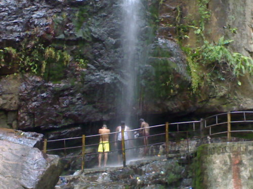
Situated in the Nagary Valley, this beautiful waterfall is worth a visit. The water here is quite rich in minerals and is said to possess curative powers.
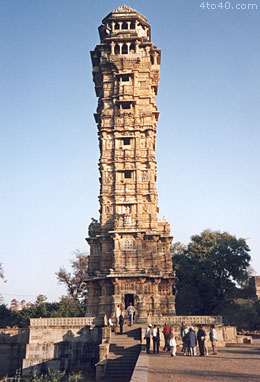
Built in 1000 AD in the form of fortifications with bastions and a steep moat, Chandragiri was under the rule of Yadavarayas for about three centuries and came into the control of Vijayanagara rulers in 1367. It rose into prominence in 1568 AD and remained as seat of power for the later Vijayanagara kings under whose reign the fortified area was further extended and some of the magnificent buildings and temples were constructed. Some of the important kavyas of Vijayanagara period are said to be composed here. In 1646 the fort was annexed into the Golkonda territory, subsequently came under Mysore rule till 1792 and went into oblivion. Inside the fortification are seen eight ruined temples of saivite and vaishnavite pantheons, Raja mahal, Rani mahal and other ruined structures.King's Palace: One of the finest examples of Indo-Saracenic architecture of Vijayanagara period, this imposing three storeyed palace adorned by the crowning towers representing certain Hindu architectural elements, was constructed with stone, brick, lime mortar and is devoid of timber. The central tower that covers durbar hall rises through two storeys. It is said to be the same venue where Sri Rangaraya granted the site of Fort St. George to the British in 1640. The floors are supported by massive pillars while the walls bear fine plaster and stucco decorations.Queen's Palace: Similar to the Kings palace in style and method of execution, this edifice with ground floor looking like a stable and first floor containing quarters adorned with ornamental sikhara has a flat roof. Contrary to the popular belief that this place was meant for the queen or harem, the epigraphical record available from the basement speaks this building being a commander’s quarters.

 Chittoor has many wild life sanctuaries nearby.\r\nPocharam: Located in area of 130 sq km, this sanctuary is situated along the shores of Pocharam Lake, near Medak. It is the natural habitat of the cheetah, wild boar, sloth bears, panther, ducks, teals, storks, partridges, quails and flamingos.\r\nGundlabrameshwaram: Around 100 kms from Kurnool, this sanctuary is spread over the vast area of around 1194 sq km. The sanctuary area is situated on Gundlabrahmeshwaram plateau running south-north from 400m msl to 911m msl with cut up and broken hill ranges, valleys and plateaus. The area presents a varied habitat for wildlife. This sanctuary forms part of the Nallamalai Hill ranges. A perennial river Gundlakamma crisscrosses through the sanctuary. The flora consists of teak, bamboo, nallamaddi, a dug chindugu, chirman, yegisa and sheesham.\r\nThe animals found here are Chital, Black Buck, sambhar, neelgai, chousingha, chinkara, mouse deer, langoor, bonnet monkey, pangolin, monitor lizard, python, mugger crocodile, jungle cat, wild dog, hyena, panther and tiger.\r\nSome other sancturaies are the Krishna, Sri Venkateshwara, Srilanka Malleswara and Kaundinga wild life sanctuaries.
 Chandragiri was the former capital of the Vijayanagara Empire. It is located at a distance of 12-km from Tirupati, in Chitoor district. The forts and Mahals at the place are attractions for tourists.
 This small village at a distance of about 8-km from Chittoor, is famous for its set of ancient temples dedicated to Mukkantisvara and Lakshminarayana which are believed to have been constructed by the Chola kings, about 1,000 years ago.
 Horsley hills are one of the famous hill resorts of Andhra Pradesh. It is named after WD Horsley, who was the collector of Cuddapah district. Horsley chose this spot for his summer residence. It is situated at an altitude of 1,265 m, which makes this place delightfully cool, with a maximum summer temperature of 32°C, and minimum of 20°C. The shady slopes found in this are wooded with luxurious vegetation.
 Situated in the Nagary Valley, this beautiful waterfall is worth a visit. The water here is quite rich in minerals and is said to possess curative powers.
 Built in 1000 AD in the form of fortifications with bastions and a steep moat, Chandragiri was under the rule of Yadavarayas for about three centuries and came into the control of Vijayanagara rulers in 1367. It rose into prominence in 1568 AD and remained as seat of power for the later Vijayanagara kings under whose reign the fortified area was further extended and some of the magnificent buildings and temples were constructed. Some of the important kavyas of Vijayanagara period are said to be composed here. In 1646 the fort was annexed into the Golkonda territory, subsequently came under Mysore rule till 1792 and went into oblivion. Inside the fortification are seen eight ruined temples of saivite and vaishnavite pantheons, Raja mahal, Rani mahal and other ruined structures.King's Palace: One of the finest examples of Indo-Saracenic architecture of Vijayanagara period, this imposing three storeyed palace adorned by the crowning towers representing certain Hindu architectural elements, was constructed with stone, brick, lime mortar and is devoid of timber. The central tower that covers durbar hall rises through two storeys. It is said to be the same venue where Sri Rangaraya granted the site of Fort St. George to the British in 1640. The floors are supported by massive pillars while the walls bear fine plaster and stucco decorations.Queen's Palace: Similar to the Kings palace in style and method of execution, this edifice with ground floor looking like a stable and first floor containing quarters adorned with ornamental sikhara has a flat roof. Contrary to the popular belief that this place was meant for the queen or harem, the epigraphical record available from the basement speaks this building being a commander’s quarters.